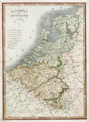
Hollande et Belgique. Holland and Belgium antique map by Monin, c1838.
$120.00
The Low countries antique map. Finely engraved antique map of Holland and Belgium, from Atlas Universel de Geographie Ancienne et Moderne published in Paris circa 1838 by Monin and Fremin.
harles V. Monin was a French cartographer who was active between 1830 and 1880. He also produced copperplate and steel engraved maps for the Petit Atlas National c1835 and Atlas Classique de la Geographie c1844-5. Antoine-Remy Fremin was a French cartographer, who also complied maps for Tardieu and Herisson atlases.
The map has fine later hand-colour. It is in excellent condition with full margins. Please note, we have shown only the map for greater detail. The map size is 23 x 28cm (9 x 11 inches).